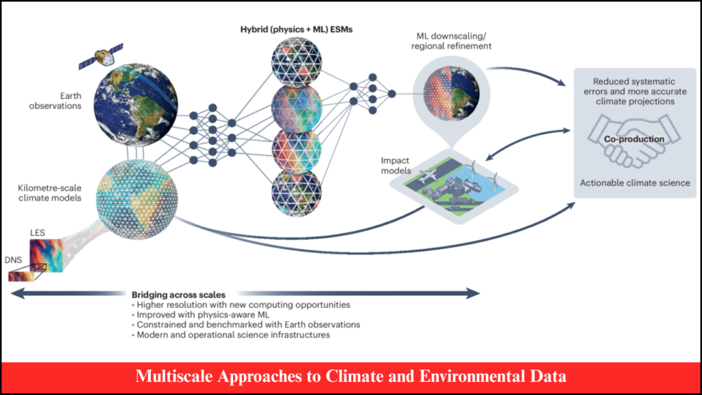
Climate and environmental systems are inherently complex, exhibiting variability across multiple spatial and temporal scales. Understanding these systems requires sophisticated methodologies that can capture interactions between local, regional, and global phenomena. Multiscale approaches, which integrate data from different resolutions and timeframes, are crucial for accurately assessing environmental changes and informing effective policy decisions. These approaches allow researchers to model environmental systems holistically, addressing both short-term variability and long-term trends, while providing actionable insights for resource management and disaster mitigation.
Table of Contents
Understanding Multiscale Approaches
Multiscale approaches analyze data across diverse spatial and temporal scales to understand complex interactions in environmental systems. Such approaches consider the interplay between micro-level processes, such as soil moisture variability in a small watershed, and macro-level patterns, like global climate change impacts. They combine observational data, satellite imagery, and model simulations to provide comprehensive insights that single-scale studies cannot offer.
Key Components of Multiscale Approaches
- Spatial Scales: Data collection occurs at multiple spatial levels, including local, regional, and global scales. This allows for the identification of patterns such as urban heat islands, deforestation hotspots, and regional drought vulnerability.
- Temporal Scales: Data analysis spans short-term (daily, seasonal) to long-term (decadal, centennial) timeframes. This helps in tracking phenomena like seasonal floods, long-term glacial retreat, and climate oscillations.
- Data Integration: Combining heterogeneous data from field sensors, satellite imagery, and climate models allows researchers to capture comprehensive environmental dynamics. Data integration ensures consistency across scales and reduces uncertainty in environmental assessments.
Applications in Climate and Environmental Studies
Multiscale approaches are applied extensively in climate and environmental research.
| Application Area | Description | Benefit |
|---|---|---|
| Climate Modeling | Integrates regional and global climate data | Improves model accuracy and predictive capabilities |
| Ecosystem Monitoring | Combines local biodiversity surveys with satellite data | Tracks ecosystem health and species distribution |
| Disaster Risk Assessment | Uses multi-scale hazard and exposure data | Enhances early warning systems and mitigation planning |
| Water Resource Management | Combines hydrological data from catchment to river basin levels | Optimizes water allocation and reduces scarcity |
| Agriculture Planning | Integrates soil, crop, and climate data | Supports precision agriculture and food security |
Techniques Used in Multiscale Analysis
- Remote Sensing: Satellite and drone technologies provide high-resolution spatial data across various scales, enabling continuous monitoring of environmental changes.
- Geostatistical Methods: Techniques such as kriging and spatial interpolation help estimate environmental variables at unmeasured locations based on nearby measurements, bridging gaps between different spatial scales.
- Multiscale Modeling: Models are developed to incorporate interactions across scales, such as coupling local hydrological models with global climate models.
- Data Assimilation: Integrates observational data into models in real-time to improve predictions and reduce uncertainty.
Case Studies Demonstrating the Effectiveness of Multiscale Approaches
Several case studies highlight the practical value of multiscale approaches in environmental research.
| Case Study | Scale Used | Outcome |
|---|---|---|
| Urban Heat Islands | Neighborhood to city scale | Identified hotspots and informed urban planning to reduce heat stress |
| Water Resource Management | Catchment to basin scale | Optimized water distribution and improved drought management |
| Biodiversity Conservation | Local to regional scale | Developed effective conservation strategies for endangered species |
| Flood Risk Assessment | River reaches the regional scale | Enhanced early warning systems and reduced damage costs |
| Agricultural Productivity | Farm to regional scale | Enabled precision agriculture, improving yield and reducing resource waste |
Challenges in Implementing Multiscale Approaches
Despite their advantages, several challenges exist:
- Data Heterogeneity: Integrating datasets from different sources, resolutions, and formats can be technically complex.
- Computational Demands: Processing and analyzing large multiscale datasets require advanced computational infrastructure and high-performance computing.
- Modeling Complexity: Developing models that accurately capture interactions across scales involves sophisticated algorithms and domain expertise.
- Uncertainty Management: Combining data and models across scales introduces uncertainty that must be carefully quantified and communicated.
Technological Advancements Supporting Multiscale Approaches
Recent technological developments have enabled more efficient and accurate multiscale analysis:
- High-Resolution Satellites: Modern satellites provide detailed spatial data at regional and local scales, enabling finer analysis of environmental variables.
- High-Performance Computing (HPC): HPC resources allow processing of large datasets, running complex simulations, and performing sensitivity analyses across scales.
- Advanced Modeling Algorithms: Machine learning and artificial intelligence techniques help integrate multi-source data and improve predictive accuracy.
- Internet of Things (IoT) Sensors: Networks of environmental sensors provide real-time data on variables such as air quality, soil moisture, and temperature at local scales.
Future Directions in Multiscale Climate and Environmental Research
Future research in multiscale climate and environmental studies is expected to focus on:
- Enhanced Data Integration: Developing standardized frameworks to combine heterogeneous data from field observations, satellites, and models.
- Improved Multiscale Models: Creating models capable of simulating cross-scale interactions, from local ecosystems to global climate systems.
- Policy and Decision Support: Using multiscale insights to develop evidence-based policies for climate mitigation, disaster risk reduction, and natural resource management.
- Cross-Disciplinary Collaboration: Integrating expertise from climatology, ecology, hydrology, and computer science to address complex environmental challenges.
- Real-Time Environmental Monitoring: Leveraging IoT sensors and satellite networks to provide continuous monitoring for adaptive management strategies.
In Summary
Multiscale approaches are essential for understanding the complexities of climate and environmental systems. By integrating data across multiple spatial and temporal scales, these methodologies provide comprehensive insights into environmental dynamics that are crucial for research, management, and policymaking. Continued technological advancements, improved modeling techniques, and enhanced data integration will further strengthen the ability of multiscale approaches to address environmental challenges, ensuring more sustainable management of natural resources and resilience against climate-related hazards.